The Landscape Fragmentation Tool v2.0 requires a 2 category land cover grid map as the input. The land cover grid should contain values of 1 for pixels representing the fragmenting land covers (i.e. urban) and values of 2 for the pixels representing the land cover type of interest (i.e. forest). Pixels with any other value will be excluded from the analysis.
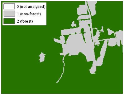
The input data required for the LFT v2.0 can be derived using ArcGIS's Reclassify tool to recode Connecticut Changing Landscape (CCL) land cover data, the National Land Cover Dataset (NLCD), or any other land cover map containing the necessary land cover types. The land cover grid must be in a GRID, IMG, or TIFF format.
A version of the LFT v2.0 tool is available that does not require Spatial Analyst extension. This version provides a tool that allows land cover data to be reclassified without using Spatial Analyst.
Detailed descriptions of the required parameters can be found in the in-Tool help documentation. This documentation is available in the help column of the dialog window and through the help page. The help page, which is accessible through the help column of the dialog window, also provides tips on properly using the tool. The interfaces for the two versions of LFT v2.0 are described below.
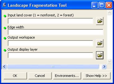
This version of LFT uses Spatial Analyst and requires a 2 class land cover grid as the input. ArcGIS's Reclassify tool can be used to reclassify the original land cover data if needed. Four parameters must be specified in the LFT v2.0 (SA) tool's dialog window:
the file name of the input 2 class land cover dataset.
the width of the edge effect (in the same units as the units in the input land cover).
the location where the output grid will be saved.
the file name of the output grid.
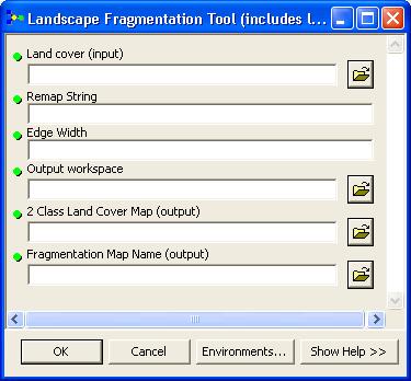
This version of LFT does not require the Spatial Analyst extension. Below, we describe the dialog window interface for the LFT v2.0 (nSA) model. This model incorporates two scripts: the first reclassifies the land cover data, the second runs the fragmentation analysis. These scripts may be run directly from the LFT toolset. The model requires 6 parameters to be set:
The land cover raster. Either the original land cover data (i.e. CCL) or the 2 class land cover may be specified. If the land cover is not already in the proper classification, you will have the option to reclassify it.
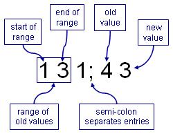
The reclassification string. If no reclassification is needed, specify 0 for this parameter. Otherwise, use command line syntax for the Reclassify tool. The syntax is as follows...
the width of the edge effect (in the same units as the units in the input land cover).
the location where the output grids will be saved.
the file name of the output 2 class land cover map
the file name of the output fragmentation map