CLEAR research primarily focuses on the use of remote sensing and related geospatial technologies to characterize, map and analyze Connecticut's changing landscape. This information is then incorporated into one or more of the Center's education programs. Of particular interest to us is the growth of developed land and its impacts on natural resources like water, forest and agriculture. Some CLEAR programs also conduct applied research on topics related to stormwater management, and recently climate change adaptation. See our Water and Land & Climate pages for more information on these projects.
Based on the Connecticut's Changing Landscape (CCL) project, this study looks at land cover change along the state's environmentally critical streamside, or riparian, corridors, during the 21 year period from 1985 to 2006.
The UConn campus is the location of the first Clean Water Act "TMDL" regulation in the nation based not on a specific pollutant, but on impervious cover. CLEAR's NEMO team leads the effort to respond.
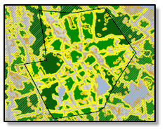
This ongoing Land Cover Change Study tracks changes in the state's landscape over time (1985-2010), with an emphasis on increases in developed land. The study has become a major resource for researchers, agency staff, communities, the public and the press.

Based on the Connecticut's Changing Landscape (CCL) project, CLEAR researchers developed a model to analyze the land cover change for information on the fragmentation of forest land, the largest component of Connecticut's land cover.
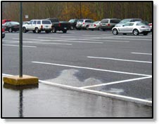
CLEAR has developed several ways to estimate the amount of impervious surface, which is known to be a good indicator of the impact of development on water resources. This site shows the results of two different techniques.
In this study conducted for the Long Island Sound Study National Estuary Program, CLEAR researchers used innovative remote sensing techniques to quantify impervious surfaces in the Connecticut and lower New York region from 1985 to 2002. Impervious surfaces like asphalt, rooftops and concrete are a reliable indicator of the impact of development on water resources.
Conducted as part of a team that included New York University and Williams College, CLEAR researchers looked at urban extent and expansion over a ten-year period for 120 cities with a population over 100,000, worldwide. This study is providing insight into the relationships of population growth and urban expansion in developing countries.
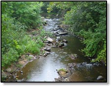
The scientific literature suggests that one of the best ways to protect water resources is by keeping riparian (streamside) corridors in a natural state. Just how much of our coastal riparian buffer areas in Connecticut are still natural, and how fast are we developing them? This study, funded by the Long Island Sound Study National Estuary Program, is using our satellite-based Connecticut's Changing Landscape data to find out.
Identify and delineate coastal marshes (CT and north shore of Long Island, NY) and distinguish various types of marsh vegetation using moderate spatial resolution public domain satellite imagery and high spatial resolution commercial remote sensing imagery combined with in situ field studies. These datasets and protocols will provide coastal resource managers, municipal officials and researchers a standardized baseline inventory of marsh location and extent for current land management and long term monitoring, as well as a set of recommended guidelines for remote sensing data collection for marsh inventory and analysis.
This study was designed to determine what has happened to land that was actively used for agriculture in 1970 in the Midstate and Connecticut River Estuary Regional Planning Areas.
Protecting lake water quality is a major concern for local, regional, and state agencies as well as citizens and non‐profit organizations. Comprehensive water quality data are essential for improved management and policy decisions. It is, however, prohibitively expensive to monitor water quality for a significant number of lakes and ponds using conventional methods.
Tidal marshes in the lower Connecticut River significantly have been altered in the last few decades from the rapid expansion of Phragmites australis, a highly aggressive invasive reed. Through collaboration with a number of academic, state, municipal and nonprofit organizations, we are investigating the use of high-resolution multi-spectral imagery and LiDAR to detect the presence of P. australis and to monitor the efficacy of eradication programs. Funded by EPA, the NOAA Coastal Services Center, the Connecticut Dept. of Environmental Protection and the Institute for the Application of Geospatial Technology.