The basic procedure to derive the forest fragmentation map is to take the land cover image (left image in the figure below) and apply a moving analysis window of a given pixel size (e.g. a 9 x 9 pixel analysis window in the figure below) to calculate values of Pf (the proportion of forest pixels in the analysis window) and Pff (how connected are those forest pixels). The values are applied to the forest fragmentation model represented in the figure below to assign a forest pixel at the center of the analysis window to one of the five forest fragmentation categories. The result is the image on the right in the figure below. For a more detailed description of the forest fragmentation procedure click on the figure below. Also, visit our publications page.
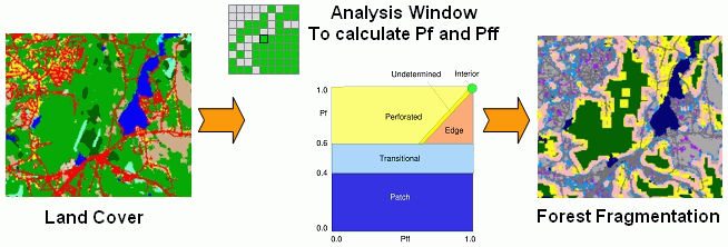 |
Basic Forest Fragmentation ProcedureThe forest fragmentation categories are defined as: |
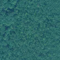 |
Interior (Core) forest:the entire area is forested. There are no non-forested land cover features in the near vacinity. Model definition: Pf = 1.0 |
|
 |
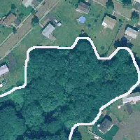
Perforated forest:the forest occurs along the interior edge of a forest tract such as would occur around a small clearing or house lot (e.g. the forested area surrounding the cleared house lot and enclosed within the boundary at right). Model definition: Pf > 0.6 and Pff - Pf < 0 |
|
 |
Edge forest:the forest occurs along the outside edge of a forest tract such as would occur along a large agricultural field or urban area (e.g. the forested area along the urbanized region and enclosed within the boundary at right). Model definition: Pf > 0.6 and Pff - Pf > 0 |
|
 |
Transitional forest:the forest is extending into a non-forested area such as would occur with forest extending into an urbanized area (e.g. the tongue of forest extending into the residential neighborhood in the area enclosed within the boundary at right). Model definition: Pf < 0.6 and Pf > 0.4 |
|
 |
Patch forest:The forest is surrounded by non-forest land cover such as would occur with a small woodlot in an urbanized area (e.g. the small woodlots enclosed within the boundaries at right). Model definition: Pf < 0.4 |