
College of Agriculture and Natural Resources
Center for Land Use Education and Research

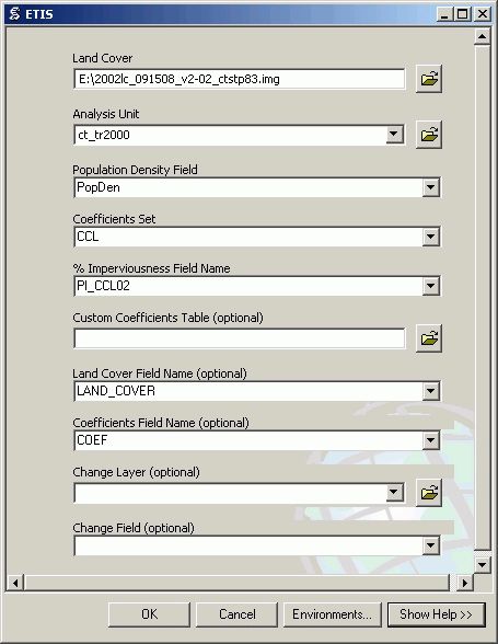
The Estimation Tool for Impervious Surface (ETIS) allows to calculate the amount of imperviousness for specified area based on land cover and population density data. It was developed using linear regression equation and a set of coefficients based on the classes of the land cover map used. There are several sets of coefficients included with the Toolbox for Connecticut Land Cover (CCL) and National Land Cover Data (NLCD) 2001, but ETIS also allows to import custom sets and to demonstrate the effect of change in land cover on the amount of imperviousness. ETIS can estimate percent impervious cover for future land cover scenarios allowing for comparison to current conditions.
ETIS was developed as an ArcToolbox for ArcGIS 9.2 and ArcView 9.2 using Python Script, but can be used with ArcGIS 9.3.
It adds a new field to the Analysis Unit shapefile for PI values to be stored in.
Jason Parent
Academic Assistant at the Department of Natural Resources Management and Engineering, University of Connecticut, Storrs, CT.
Dr. Daniel L. Civco
Professor of Geomatics at the Department of Natural Resources Management and Engineering, University of Connecticut, Storrs, CT. Dr. Civco is an earth resources scientist with considerable experience in remote sensing and GIS applications. Dr. Civco is Director of the Center for Land use Education And Research (CLEAR) at the University of Connecticut, and is the founder of its Laboratory for Earth Resources Information Systems (LERIS).
Anna Chabaeva
Research Assistant at the Department of Natural Resources Management and Engineering, University of Connecticut, Storrs, CT.
Back to Top